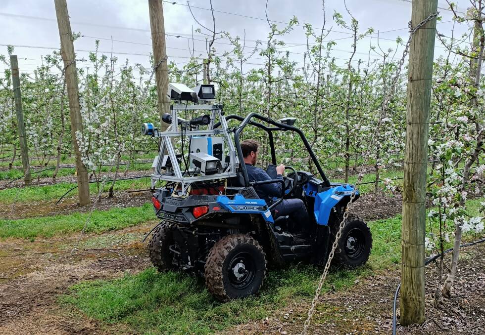
A PROJECT will evaluate the effectiveness of orchard mapping and monitoring technology to see if it has commercial viability for Western Australian orchards.
The WA Department of Primary Industries and Regional Development (DPIRD) and Pomewest, a sub-committee of the Agricultural Produce Commission, have joined together to undertake a pilot project at a commercial apple orchard near Manjimup.
The one year project will examine the technology developed by Australian company Green Atlas, which uses a combination of light detection and ranging (LiDAR) remote sensing data and digital images to map and monitor orchard growth, with in-kind support from local supplier Aero Vines.
The project is evaluating the use of the technology to inform orchard thinning and improve the management of the number of fruit on trees, known as crop loads.
Department fruit and perennial crops lead Dario Stefanelli said most crop load levels and fruit quality are regulated by canopy size and light exposure.
RELATED READING
"Maintaining a consistent and sustainable crop load of high quality is fundamental to fruit size, colour and sweetness," Dr Stefanelli said.
"Managing canopy variability is almost impossible with current visual methods, however, this new technology has the potential to greatly improve canopy management by providing localised information to tailor thinning practises.
"This research will examine whether digital mapping and monitoring technology could become a valuable tool for growers to help plan and implement orchard management techniques to reduce production costs and increase profitability."
Small scale field trials to test the technology commenced pre-flowering and data will be collected throughout the growing season from about 30 Rosy Glow apple trees (fruit marketed as Pink Lady) and the variety ANAPB 01 (fruit marketed as Bravo).
Up to 10 data collections will be undertaken to map and monitor flowering, canopy growth, fruit numbers, growth and colour development.
At least 10 trees will be manually assessed to ground proof the data from the digital technology.
The project will also examine algorithms for canopy management, including size and fruit number predictions, as well as quality parameters, including sweetness, firmness and colour, to aid orchard management decisions.
This project is a prime example of how the industry is working in collaboration with DPIRD to examine and test leading edge technologies to improve the productivity, capability and capacity of our orchards.
- Nardia Stacy, executive manager, Pomewest
"Identification early in the season of the optimal crop load supported by the canopy will allow trees to use carbohydrates more efficiently, to improve fruit size and quality," Dr Stefanelli said.
"The ability to identify optimal crop load through independent methodology will enable growers to achieve consistent fruit quality throughout the life of the orchard, reducing alternate bearing and improving overall profitability.
"Testing this technology will aid early adoption, boosting growers' competitiveness, while also creating opportunities to create new technology service industries to the benefit of industry and the regions."
Pomewest executive manager Nardia Stacy said the industry's investment in the project had been made possible by contributions from Western Australian apple and pear growers.
"We are delighted to take the opportunity to partner with DPIRD in this project to benefit the pome industry," she said.
"This project is a prime example of how the industry is working in collaboration with DPIRD to examine and test leading edge technologies to improve the productivity, capability and capacity of our orchards.
"This initiative supports Pomewest's vision to invest in initiatives that promote profitability and a sustainable future, along with strategies to meet market requirements and consistently satisfying customers with high quality fruit."
The findings from the project will be shared with industry at future field days and forums.
Sign up here to Good Fruit and Vegetables weekly newsletter for all the latest horticulture news each Thursday...

