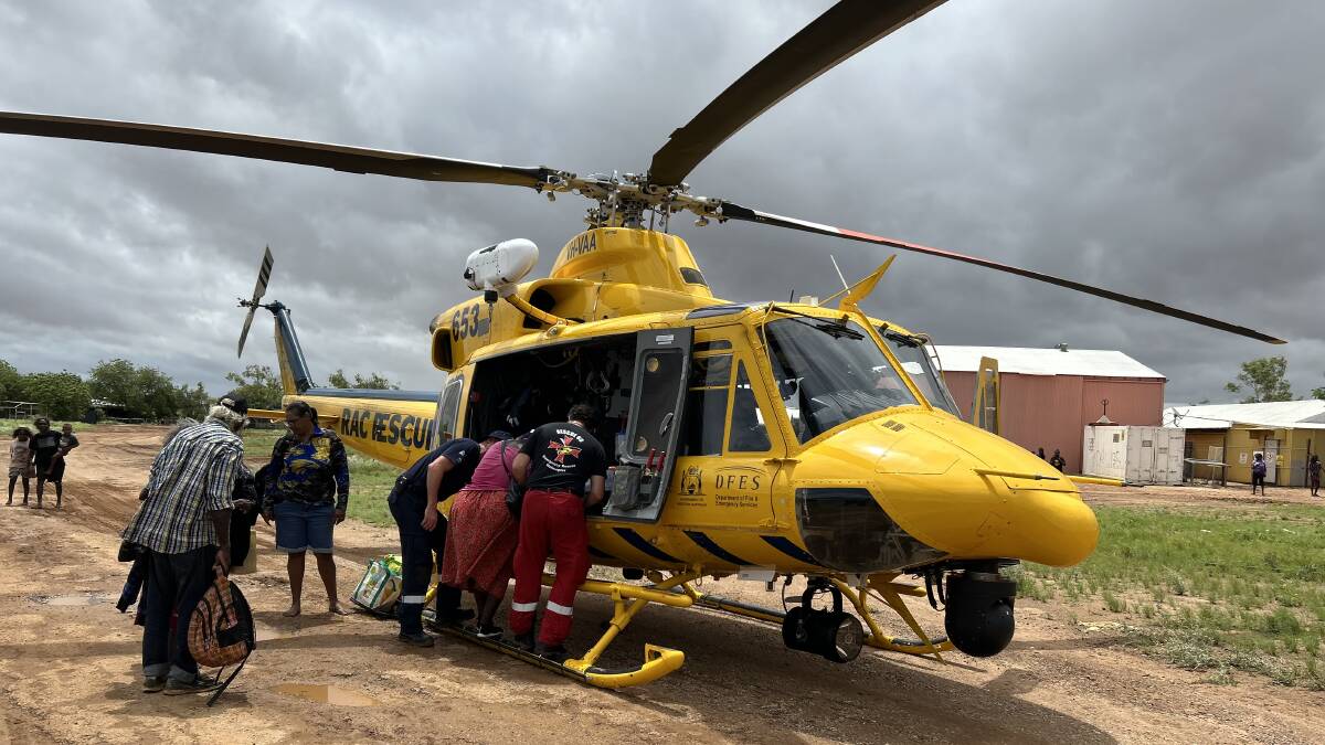
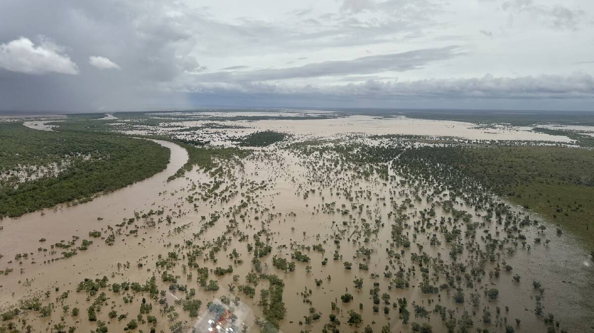
The Fitzroy Crossing flood emergency has been described by the Emergency Services Minister Stephen Dawson as the "worst ever" flood Western Australia has seen.
The river peaked at 15.81 metres this morning, and record flood levels are expected at all towns downstream - including Broome and Derby.
It is predicted in some areas the river could become 50 kilometres wide in the next five to six days.

Authorities said this afternoon that receding flood waters would allow Australian Defence Force planes to land in Fitzroy Crossing and assist with evacuation efforts.
There have been some civilians from communities on the outskirts of Fitzroy Crossing who have refused evacuation, with Fire and Emergency Services Commissioner Darren Klemm saying there will be no forced evacuations and DFES will do its best to ensure the safety of these civilians.
EARLIER
UPDATE AT 9.13AM
UPDATE AT 7.50AM
EARLIER
The Department of Fire and Emergency Services WA are urging residents to take action now for major flooding in parts of the Kimberley.
In a statement, DFES warned people to be prepared for more flooding.
"People in Fitzroy River catchment need to take action now as major flooding is expected today," the statement, released on Thursday morning, read.
"This includes people in Fitzroy Crossing, Mount Barnett and Christmas Creek.
"Please note there is a community meeting for the Fitzroy Crossing Community at 11am on Thursday 5 January at the Fitzroy Crossing Evacuation Centre, 101 Fallon Road.
"There is a possible threat to lives and homes due to rising water levels in local rivers and streams. Water will be fast flowing and levels will rise quickly."

WHAT TO DO:
- Watch for changes in water levels so you are ready if you need to evacuate.
- Pack an emergency kit, including warm clothes, valuables, important papers, canned food and water in waterproof bags.
- Ensure you have supplies and medication for an extended period.
- Make sure everyone in your family is wearing strong shoes and suitable clothing.
- Disconnect power, water and gas supplies.
- Secure loose objects and outdoor equipment.
- Relocate equipment and livestock so they do not get caught in floodwaters.
- Prepare pet food or stockfeed in case you cannot return home for a few days.
- Never walk, swim or play in floodwaters as they are dangerous.
- Do not go near storm drains and pipes, ditches and ravines, as they are dangerous.
- Stay out of rivers, this includes no swimming or kayaking.
- If you are a traveller do not park or camp adjacent to rivers.
- Make sure your neighbours have received this warning.
- Follow directions from emergency services personnel

IF DRIVING:
- Floodways and river levels may rise rapidly so be careful at crossings.
- Obey road closure signs and do not drive into water of unknown depth and current.
- Take care on gravel and unsealed roads as they may be slippery and muddy, and you could get bogged.
- If your car stalls in rising water, abandon it immediately and seek shelter above floodwater.
For more information visit www.emergency.wa.gov.au
SAFER PLACE:
The Department of Communities has set up an evacuation centre at Fitzroy Crossing Recreation Centre, 101 Fallon Road, Fitzroy Crossing.
Please take any essential items such as medications and identification to the evacuation centre.
Pets (except recognised assistance animals) are not allowed inside evacuation centres for health and safety reasons, so you should make alternative arrangements for them.
COMMUNITY MEETING
There is a community meeting for the Fitzroy Crossing Community at 11am on Thursday 5 Jan at the Fitzroy Crossing Evacuation Centre, 101 Fallon Road.
REGISTER.FIND.REUNITE:
Register with Register.Find.Reunite to let your family and loved ones know you're OK, where you are located and to enquire about a loved one's whereabouts.
You can register from any computer or mobile device or in person at a temporary evacuation centre.
- Subscribers have access to download our free app today from the App Store or Google Play
- Not already a digital subscriber? Sign up for as little as $3.75 a week
ROAD CLOSURES:
Roads have been closed including:
- Gibb River Road between Meda Turnoff, West Kimberley and Great Northern Highway, East Kimberley.
- Great Northern Highway between Fitzroy Crossing and Halls Creek at Two Mile and Blue Bush.
- Great Northern Highway between Derby / Great Northern Highway intersection and Fitzroy Crossing.
- Great Northern Hwy between Brooking Channel Bridge and Fitzroy Crossing Lodge. Do not cross Fitzroy Crossing bridge
- Broome/Derby Highway (Great Northern Highway) closed between Roebuck and Willare.
Other parts of Great Northern Highway may also be impacted over the next 48 hours.
Numerous local roads.
- Roads open but mnonitor conditions and exercise extreme caution due to water/debris over road:
- Great Northern Highway between Sandfire and Roebuck may close.
- Broome-Cape Leveque Road vicinity of Lombadina turn off.
Anticipated road closures:
- Great Northern Highway between Sandfire and Roebuck Roadhouse MAY close in 12-24 hours
Take extra care on the roads and do not drive into water of unknown depth and current.
Road information may also be available from Main Roads WA by calling 138 138 or visiting Travel Map or by contacting your Local Government Authority.
WATER:
The Water Corporation advises that residents in Fitzroy Crossing, Noonkanbah, Willare and Pandanus Park should avoid contact with floodwaters which may have been contaminated by wastewater due to heavy rainfall. Should contact occur, follow basic hygiene practices including washing affected areas of the body thoroughly with clean warm water and soap, and disinfecting open wounds.
AUDIO INFORMATION IN KRIOL:
Audio information is available in Kriol on DFES YouTube via this link: https://youtu.be/gF_Ala-waV0
FLOOD DETAILS:
As at 05/01/2023 06:48:00 the Bureau of Meteorology advises
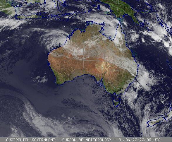
Ex-Tropical Cyclone Ellie is located immediately east of Broome and is expected to become slower moving over the next 24 hours, before finally moving steadily to the east during Friday.
Record breaking major flooding is occurring at Fitzroy Crossing.
Fitzroy crossing peaked around 15.81 metres Wednesday afternoon. The main flood peak along the Fitzroy River is currently approaching Noonkanbah where moderate flooding is occurring and major flooding is possible from late Thursday into Friday.
Downstream of Noonkanbah moderate flooding is occurring at Fitzroy Barrage with major flooding likely Thursday morning. The river level at Looma is currently below the minor flood level with minor flooding possible Friday into Saturday. Minor flooding is possible at Willare from Friday, with further rises expected towards the weekend.
Seven-day rainfall totals of 200-800 mm have been recorded across the Kimberley Region to Wednesday evening. Rainfall has eased across the catchment with the movement of Ex-Tropical Cyclone Ellie further west towards Broome.
River level rises and areas of flooding are adversely affecting road conditions in the Fitzroy River catchment. Some roads are impassable and some communities are now isolated.
Fitzroy River to Fitzroy Crossing: Major flooding is occurring along the Fitzroy River to Fitzroy Crossing.
The Fitzroy River at Fitzroy Crossing peaked at 15.81 metres around 01:10 pm Wednesday and is currently at 15.49 metres and falling, with record major flooding. The Fitzroy River at Fitzroy Crossing is expected to remain above the major flood level (12.50 metres) until Saturday morning.
Fitzroy River from Fitzroy Crossing to Noonkanbah: Major flooding is possible along the Fitzroy River from Fitzroy Crossing to Noonkanbah.
The Fitzroy River at Noonkanbah is currently at 12.32 metres and rising, with moderate flooding. The Fitzroy River at Noonkanbah may exceed the major flood level (13.00 metres) late Thursday, with the possibility of reaching 14.00 metres during Friday with major flooding.
Fitzroy River from Noonkanbah to Willare: Moderate flooding is occurring along the Fitzroy River at Fitzroy Barrage where major flooding is likely from Thursday morning. Minor flooding is possible at Looma from Friday. Minor flooding is possible at Willare from Friday into the Weekend.
The Fitzroy River at Willare is currently at 7.42 metres and rising slowly, below the minor flood level. The Fitzroy River at Willare is likely to reach the minor flood level (8.00 metres) Friday into Saturday.
Please note there are currently separate flood warnings/watches for:
- Fitzroy River catchment for people in Noonkanbah, Looma and Willare
- West Kimberley District
- Northern parts of the Sandy Desert
Current river levels are available from the Department of Water and Environmental Regulation.
For the latest flood information visit www.bom.gov.au/wa/flood or call 1300 659 213.
WHAT EMERGENCY SERVICES ARE DOING:
DFES is working closely with other relevant agencies, with the priority being preservation of life and safely evacuating people from impacted areas.
Weather conditions are making it difficult for aircraft to operate. DFES will continue to undertake evacuations where possible but people need to understand that this could take time. DFES is bringing in more aircraft to bolster our evacuation and resupply efforts as some communities may be isolated for at least a week.
DFES is currently responding to 21 requests for assistance across the region.
Over the coming days, emergency services will need to fly essential supplies to communities cut off by flood water and provide other urgent assistance.
Australian Defence Force resources have been engaged for flood operations. Re-supply of food and medical supplies is occurring where possible.
IMPORTANT NUMBERS:
For SES assistance call 132 500.
In a life threatening situation call 000.
For the latest flood information call 1300 659 210 or visit bom.gov.au/wa/flood.
EXTRA INFORMATION:
People who planned to travel to central or eastern Kimberley over the coming weeks are recommended to reconsider or delay their travel plans.
An Emergency Situation has been declared. For more information visit the DFES website
Floodwaters can contain rubbish, snakes, dead animals, sewerage, live power and other contaminants. Avoid entering flood waters.
Take precautions with wildlife, domestic or livestock animals disturbed by flood waters.
Ensure safe food handling procedures and disease and/or infection practices are managed.
Phone services have been impacted across the following areas:- Durack, Lake Argyle, Mueller Ranges, Willare, Whydham and Ord River.
Residents should prepare for the loss of electronic banking and services.
KEEP UP TO DATE:
Visit Emergency WA, call 13 DFES (13 3337), follow DFES on Twitter, Facebook, listen to ABC Local Radio, 6PR, or news bulletins. During a power outage, your home phone, computer or other electronic devices connected to the NBN will not work. Include a battery powered radio in your emergency kit.
Updates will be provided when the situation changes.
For more information visit www.emergency.wa.gov.au
READ MORE:


